
The Camino de Santiago is a network of pilgrim routes across Spain, Portugal and France, and every one of them ends at the cathedral in Santiago de Compostela. The most popular are the Camino Francés (about 770 km), the Camino Portugués (about 240 km from Porto, or 620 km from Lisbon), the Camino del Norte (about 825 km) and the Camino Inglés (about 120 km). To earn the Compostela certificate, walk at least the last 100 km or cycle the last 200 km into Santiago. All the maps below are free to download.
Spread a map of the Camino out on the kitchen table and something happens. Lines start in Lisbon, in Seville, at the foot of the Pyrenees and in the green hills of Asturias. They wind past cathedrals, vineyards and fishing harbours. And every one of them leads to the same square in Santiago de Compostela.
That is the magic of the Camino de Santiago. It is not one path but a whole web of them, walked by pilgrims for more than a thousand years. On this page you will find a clear map of every main route, with real distances, an elevation profile showing the climbs, and the town where the last 100 km begins.
Camino de Santiago map: all the main routes
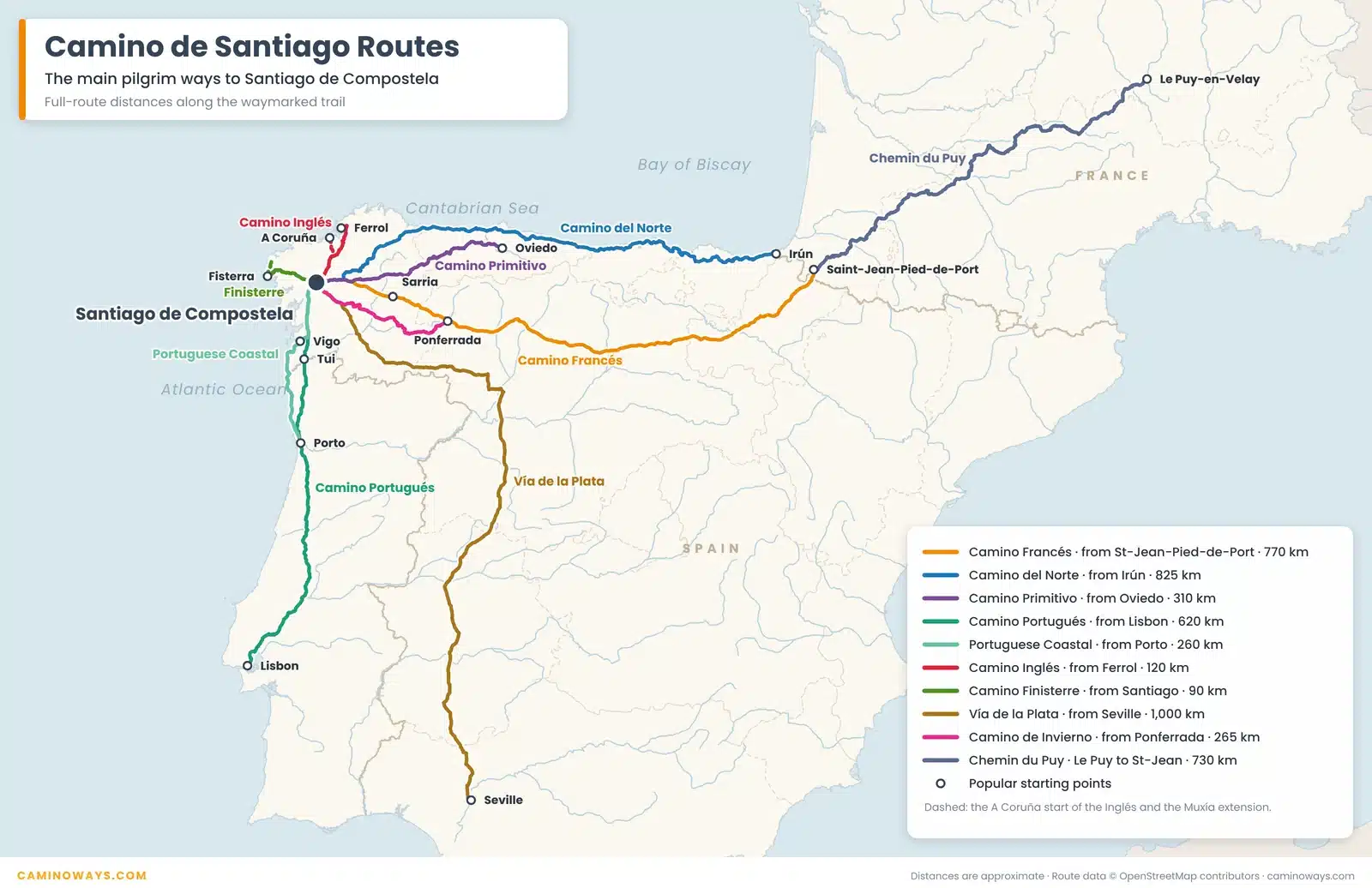
Walking a whole Camino route can take anything from a week to more than a month. But you do not need to walk all of it. To earn your Compostela, you only need to walk the last 100 km into Santiago, which takes about a week on most routes.
Camino routes at a glance: distances and nights
How far is each route, and how long does it take? Here are the main routes on the map, with the full distance and the town where you can start your last 100 km.
| Route | Starts in | Full route | Last 100 km starts in |
|---|---|---|---|
| Camino Francés | Saint-Jean-Pied-de-Port | About 770 km, up to 35 nights | Sarria: about 115 km, 6 nights |
| Camino Portugués (Central) | Lisbon or Porto | About 620 km from Lisbon, up to 29 nights. About 240 km from Porto, up to 13 nights | Tui: about 115 km, 6 nights |
| Portuguese Coastal Way | Porto | About 260 km from Porto, up to 13 nights. About 640 km from Lisbon | Vigo: about 100 km, 6 nights |
| Camino del Norte | Irún or San Sebastián | About 825 km from Irún (800 km from San Sebastián), 38 nights | Vilalba: about 125 km, 7 nights |
| Camino Primitivo | Oviedo | About 310 km, up to 15 nights | Lugo: about 100 km, 6 nights |
| Camino Inglés | Ferrol or A Coruña | About 120 km from Ferrol, 6 nights. About 75 km from A Coruña | Ferrol: the whole route |
| Camino Finisterre | Santiago de Compostela | About 90 km to Fisterra, or about 120 km with Muxía, 5 nights | Starts in Santiago |
| Vía de la Plata | Seville | About 1,000 km | Ourense: about 105 km, 7 nights |
| Camino de Invierno | Ponferrada | About 265 km | Monforte de Lemos: about 135 km, 7 nights |
| Variante Espiritual | Pontevedra | Two days of walking, a boat trip, then on to Santiago | Part of the last 100 km of the Camino Portugués |
| Chemin du Puy | Le Puy-en-Velay | About 730 km to Saint-Jean-Pied-de-Port, up to 32 nights | Continues as the Camino Francés |
Nights are for CaminoWays itineraries and depend on your pace. For a plan made just for you, try our Camino Planner.
How to read these maps
Every route map on this page works the same way, so you can compare them at a glance:
- Orange line: the route itself, drawn from the waymarked trail.
- Dark blue line: the last 100 km (or a little more) into Santiago, the part you need to walk for your Compostela.
- Grey dotted lines: the other Camino routes nearby, so you can see where they meet.
- Elevation profile: the chart under each map shows the ups and downs, with the distance to each main town.
Distances are approximate. Your own daily totals may be a little longer, depending on where you stay each night.
The Camino de Santiago routes, one by one
1. Camino Francés map
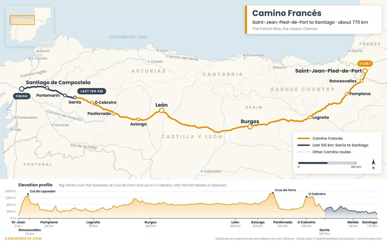
The Camino Francés is the classic Camino and by far the most loved: almost half of all pilgrims walked it in 2025, according to figures from the Pilgrim’s Office (see our Camino statistics). It begins in Saint-Jean-Pied-de-Port in France and climbs straight over the Pyrenees to Roncesvalles. From there it crosses northern Spain through Pamplona, Burgos and León, over the wide, quiet Meseta, and up to O Cebreiro, your first taste of Galicia.
Most people walk the last 100 km from Sarria. It is busy and full of life, with cafés, friendly bars and a real sense of community. Don’t forget to try pulpo, Galician-style octopus, in Melide.
2. Camino Portugués map (Central Way)
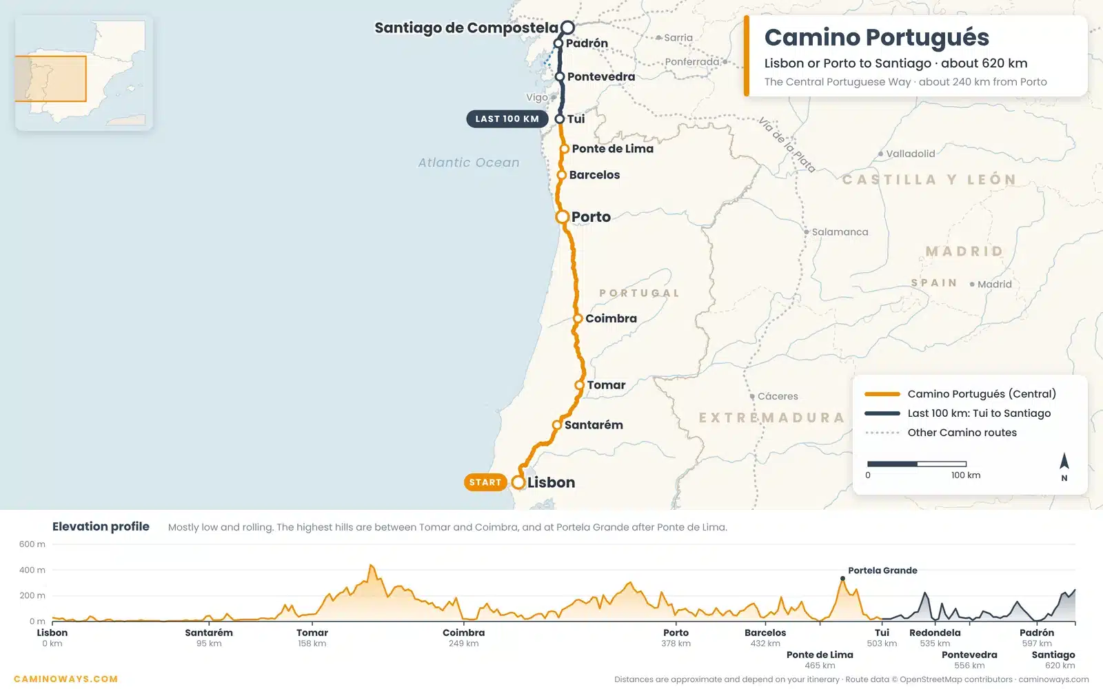
The Camino Portugués is the second most popular route. You can start in Lisbon, but most pilgrims begin in Porto and walk about 240 km north through green countryside, vineyards and stone villages. Highlights include Barcelos and Ponte de Lima, one of Portugal’s oldest towns, before you cross the River Minho from Valença into Spain at Tui.
The last 100 km starts in Tui. The walking is mostly gentle, and the route is quieter and more rural than the Camino Francés.
3. Portuguese Coastal Way map
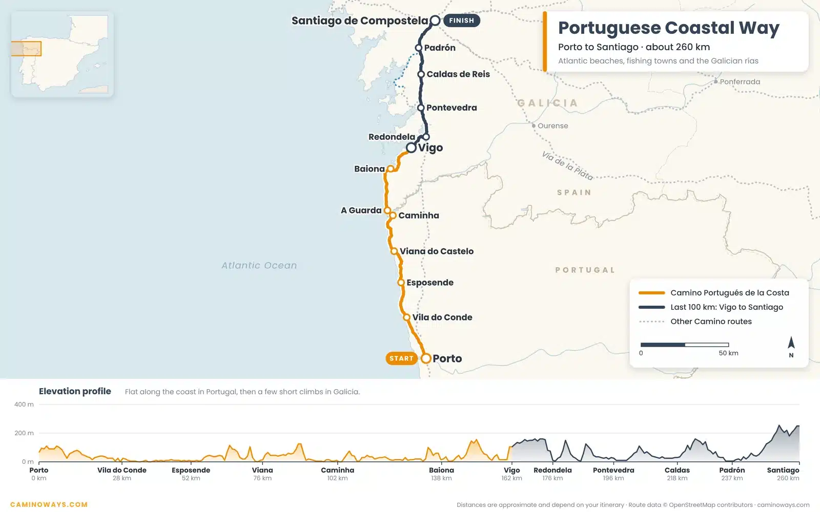
The Portuguese Coastal Camino from Porto follows the Atlantic: sandy beaches, sea breezes and fishing towns like Vila do Conde, Esposende and Viana do Castelo. You cross into Spain at A Guarda, then walk on to Baiona and Vigo before joining the Central Way at Redondela.
It is now the third most popular route and the fastest growing, up 20% in 2025. The last 100 km starts in Vigo, and the profile shows why people love it: it stays low and flat for most of the way.
4. Camino del Norte map
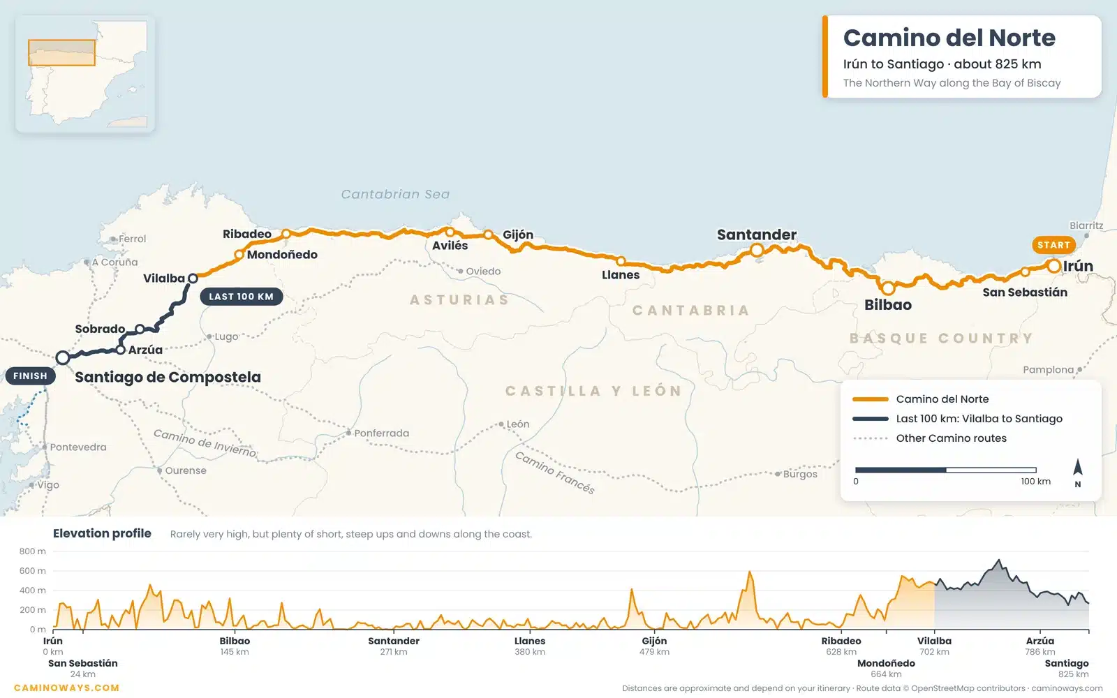
The Northern Way follows Spain’s north coast from Irún and San Sebastián, through the Basque Country, Cantabria and Asturias. Expect cliffs, beaches and lively cities: try the famous pintxos in Bilbao and stroll the seafront in elegant Santander. After Ribadeo the route turns inland through Galicia and joins the Camino Francés at Arzúa.
It is rarely very high, but there are plenty of short, steep climbs, so it suits walkers with some experience. The last 100 km starts in Vilalba.
5. Camino Primitivo map
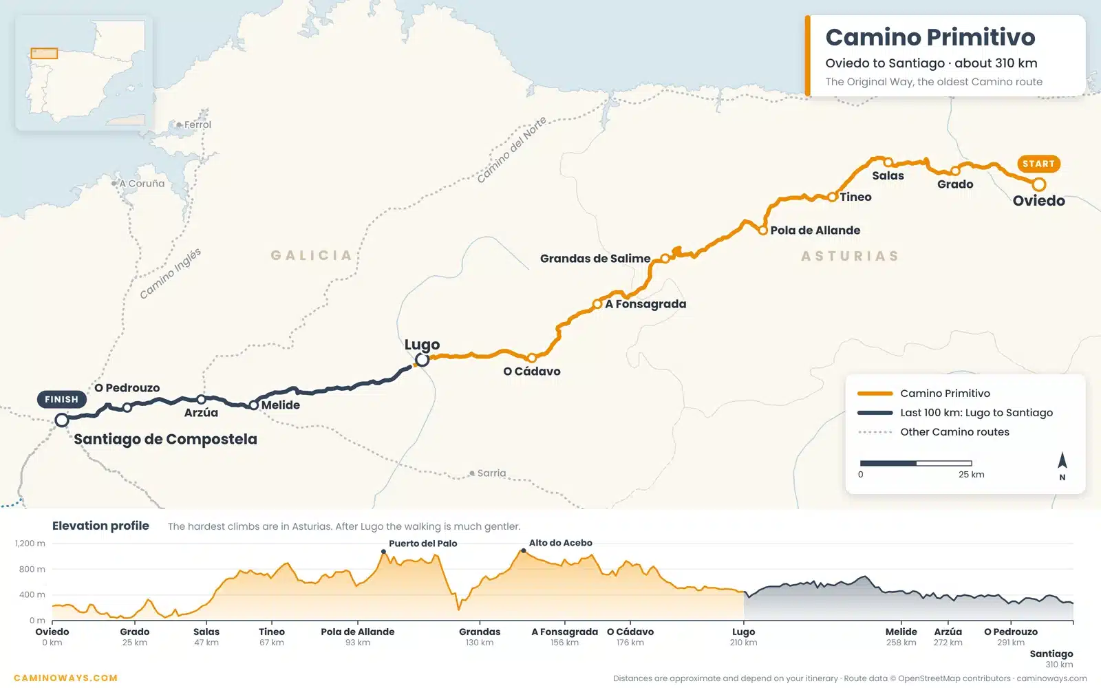
The Camino Primitivo, or Original Way, is the oldest Camino of all, first walked by King Alfonso II of Asturias in the 9th century. It runs about 310 km from Oviedo through the mountains of Asturias and Galicia, with big climbs at Puerto del Palo and Alto do Acebo.
The last 100 km starts in Lugo, where you can walk along the complete Roman walls before heading on to Melide, where the Primitivo joins the Camino Francés.
6. Camino Inglés map
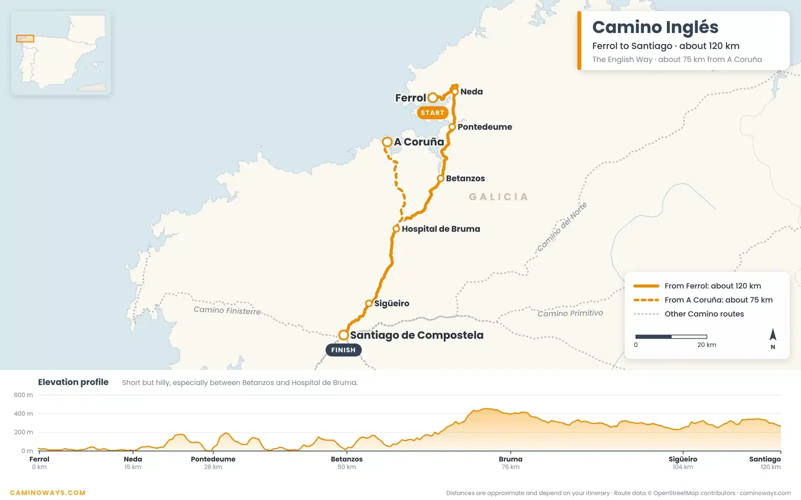
The English Way follows the path of pilgrims from Britain, Ireland and northern Europe, who sailed into the ports of Ferrol and A Coruña. From Ferrol it is about 120 km to Santiago, through seaside towns like Pontedeume and Betanzos, then over green hills to Hospital de Bruma.
From A Coruña it is only about 75 km. That is less than 100 km, so to earn the Compostela you first walk a recognised stretch at home, such as the Celtic Camino in Ireland, and bring your stamps.
7. Camino Finisterre map
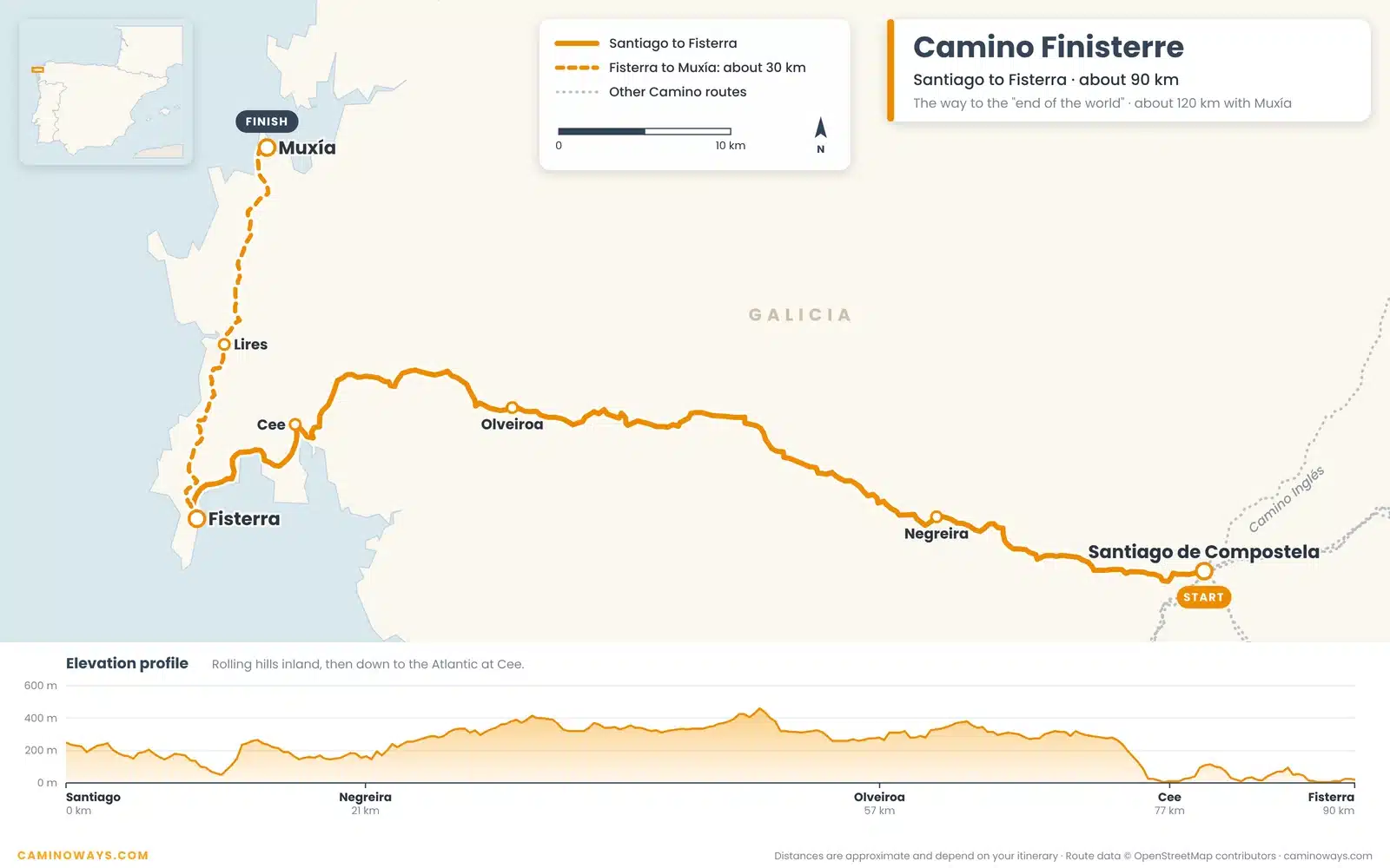
The Camino Finisterre is the only route that starts in Santiago. It heads west for about 90 km to Cape Fisterra, once believed to be the end of the world, where many pilgrims watch the sun set into the Atlantic. You can carry on for about 30 km along the coast to Muxía, about 120 km in all.
There is no Compostela for this route, but you can collect a certificate of your own: the Fisterrana in Fisterra or the Muxiana in Muxía.
8. Vía de la Plata map
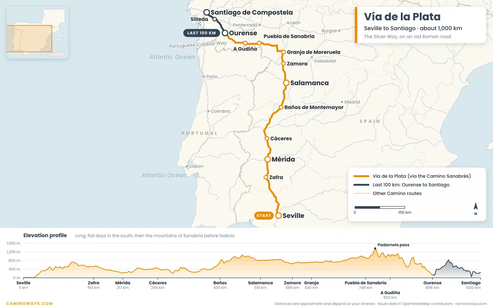
The Vía de la Plata, or Silver Way, is the longest Camino: about 1,000 km from Seville. It follows an old Roman road north through Mérida, Cáceres, Salamanca and Zamora, then turns west on the Camino Sanabrés through the mountains of Sanabria and into Galicia.
The south is hot and flat, so spring and autumn are the best times to walk it. The last 100 km starts in Ourense, a city famous for its hot springs.
9. Camino de Invierno map
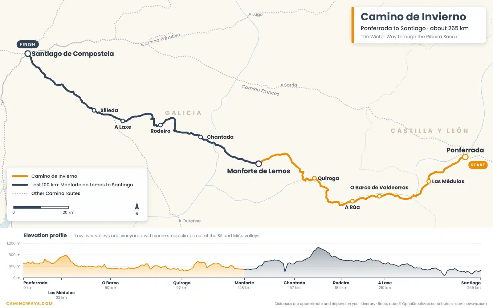
The Camino de Invierno, or Winter Way, leaves the Camino Francés at Ponferrada. Pilgrims used it in winter to avoid the snow on O Cebreiro. It passes the old Roman gold mines of Las Médulas and follows the Sil valley into the Ribeira Sacra, with its steep vineyards and quiet monasteries.
It is about 265 km long, and the last 100 km starts in Monforte de Lemos. Few pilgrims walk it, so expect peaceful days and a warm welcome.
10. Variante Espiritual map
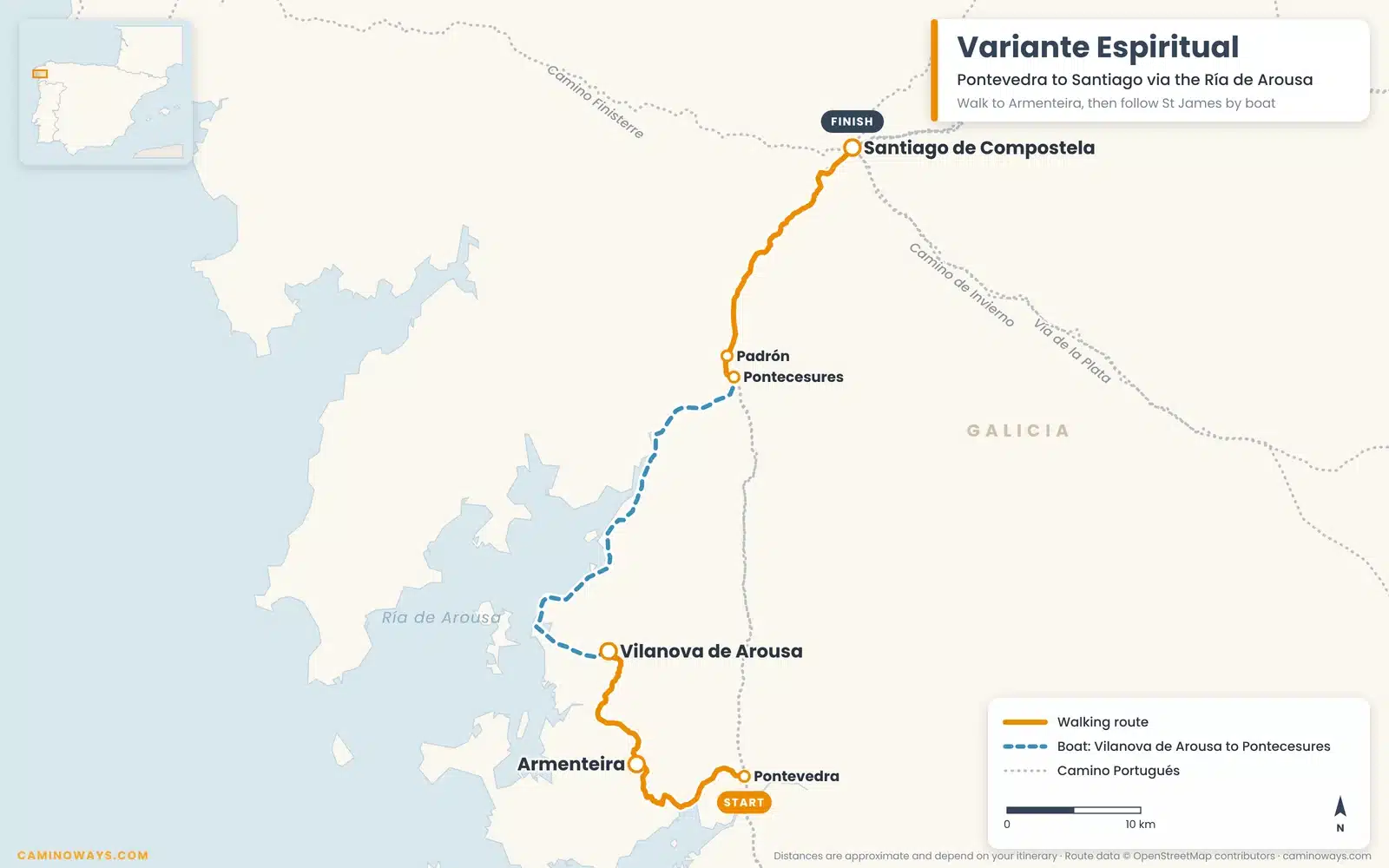
The Variante Espiritual leaves the Camino Portugués just after Pontevedra. You climb to the monastery of Armenteira, then follow a lovely path of streams and old water mills down to Vilanova de Arousa.
From there you take a boat up the Ría de Arousa and the River Ulla to Pontecesures, retracing the legendary journey of St James’ remains, the Traslatio. You then rejoin the Portuguese Way at Padrón for the final walk into Santiago.
11. Chemin du Puy map
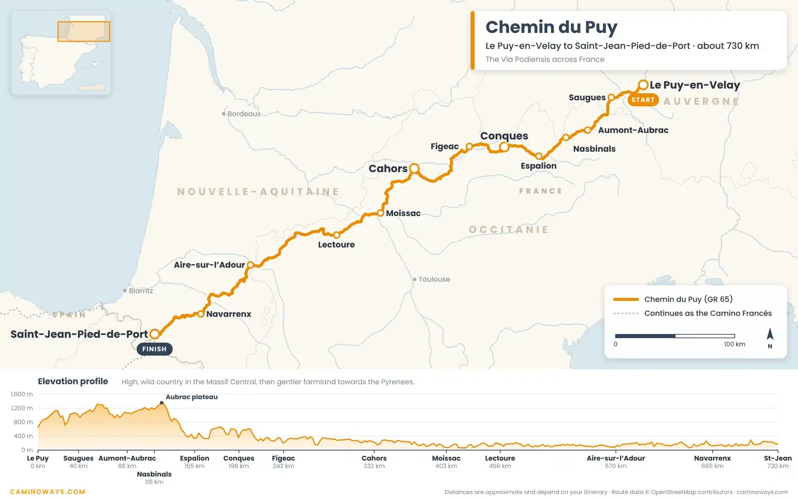
Le Chemin du Puy, or Via Podiensis, is the best-known Camino in France. It runs about 730 km from Le Puy-en-Velay to Saint-Jean-Pied-de-Port, where the Camino Francés begins.
The first days cross the high, wild Aubrac plateau. Then come some of France’s loveliest villages and towns: Conques with its abbey, Cahors with its medieval bridge and Moissac with its famous cloister.
Paper, phone or app: which map do you need?
Good news: you don’t need to be an expert map reader. The Camino is very well marked on the ground with yellow arrows and scallop shells, so most pilgrims rarely need a map to find the way.
Maps are most useful before you go: to choose your route, plan your stages and see where the climbs are. On the trail, a map on your phone is handy for finding your hotel or a café, and a printed copy is a good backup if your battery runs low.
If you travel with CaminoWays, you won’t need to plan any of this yourself. You get route notes and maps for every stage, hand-picked hotels, luggage transfers so you can walk light, and 24/7 support while you walk.
Related reading
- Camino de Santiago statistics: which routes pilgrims walk
- How to start your Camino Portugués in Porto
- Walking the Camino de Santiago: a beginner’s guide
- Camino fitness plan and Camino packing list
You can also download our Camino Beginners Guide and Camino Fitness eBook free of charge.
FAQs: Camino de Santiago maps and routes
Right here: every map on this page has a free PDF download, from the overview of all routes to a detailed map of each one. CaminoWays clients also receive stage-by-stage route notes and maps.
It depends on your route: Sarria on the Camino Francés, Tui on the Camino Portugués, Vigo on the Coastal Way, Lugo on the Primitivo, Vilalba on the Norte and Ferrol on the Inglés. From any of these, it takes about a week to walk to Santiago.
The Camino Francés is perfect for a first, sociable Camino. The Portuguese Coastal Way is ideal for sea views, the Camino del Norte and Primitivo suit experienced walkers, and the Camino Inglés is great for a short trip. Our travel specialists can help you choose.
Not really. The Camino is very well marked with yellow arrows and shells. A map is most useful for planning your stages and as a backup on the trail.
The last 100 km takes about a week. Full routes take from about a week (Camino Inglés) to five weeks or more (Camino Francés, Camino del Norte or Vía de la Plata).
👉 If you’d like a personalised itinerary, try our Award Winning Camino Planner.


Nice
My first time having a look. Thanks for the great intro!